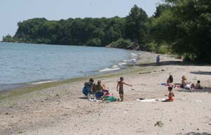
too high, just right? An overflow crowd of nearly 250 Lake Ontario area residents jammed the Greece Town Hall to listen to and speak about proposed new plans to regulate water levels in the lake by controlling outflow through the St. Lawrence River. The Greece public hearing was just part of the Lake Ontario - St. Lawrence River Study Board community forum for public comment on developing a new regulatory plan to control water levels. The study is a bi-national effort of over 150 experts from science, government, native communities, businesses and special interest groups committed to public understanding of the cause of the water level problems, and adopting a modified plan to better meet the lakefront community's needs. It's taken nearly five years of technical studies and public hearings in the United States and Canada to arrive at the three proposed 'candidate' plans to be used in making its report and recommendations to the International Joint Commission which will make changes to the regulations of water levels and outflows from Lake Ontario through the St. Lawrence River. Water levels in the Great Lakes and St. Lawrence River have been a complicated and contentious issue ever since the creation of the St. Lawrence Seaway which officially opened in 1959. Before then, water levels were determined by nature and the seasonal cycles of rain and evaporation. Water from all five Great Lakes flows into Lake Ontario and eventually out to sea through the St. Lawrence River. It was only with the Seaway dams built to improve navigation through the St. Lawrence that water levels became a serious public policy issue because, for the first time, water levels could be mechanically manipulated. The earliest plan to artificially regulate and control water levels was implemented in 1958. Since then, conflicting interests have competed and sometimes quarreled over too low or too high water levels. Commercial navigation - shipping - wants high levels to maximize the number of days ships can pass throughout the St. Lawrence River. Hydro electric power producers prefer a constant level in order to most efficiently produce electricity. Fishermen and marina owners generally like high water levels, lake front property owners want low levels so as to protect their shorefront property from erosion and damage, and environmentalists are concerned about either too high, or too low levels that endanger wildlife and the natural habitat that is the breeding ground for flora and fauna. The Water Level Study Group has been working to reconcile these various interests and, having heard from anyone wanting to plead one point of view or another, it is just about ready to make its recommendations. Public comments are still welcome until August 5. Focus on Hamlin While Hamlin does not demonstrate all the special interests - there is no commercial shipping or hydroelectric industry for instance - it does fairly represent the three most prominent concerns of lakeshore communities.
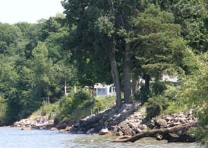
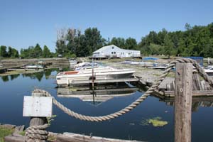
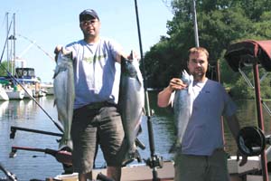
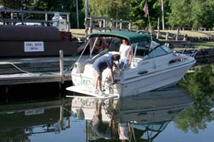
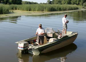
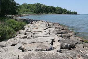
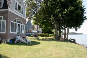
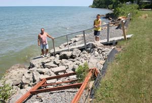
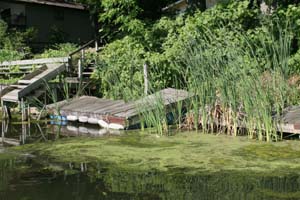
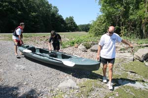
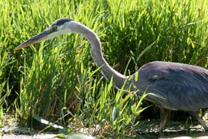
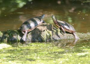
Hamlin's Town Supervisor Austin Warner knows that his town's economic vitality is tied in a lot of ways to Lake Ontario. He hears about the problems Hamlin taxpayers have when high water levels threaten their waterfront property or floods cause damage. Warner says, "The lake brings a lot of folks to town, to the park (Hamlin Beach State Park), marinas and the yacht club and to fish." Development and new residents building new homes is linked, too, to proximity to the lake. But he also knows, through participation in some of the open meetings of the Water Level Study Group, that not all lakefront communities share the same concerns. "It was interesting," he says, "to listen to people in Montreal where they were concerned more about eels and flooding. It's always good when you have the public involved and come out to comment." Shorefront property owners Goodrich remembers summers when the water level was so low he would wade for yards and yards to get to waist high water sufficient to swim in. And, he also remembers spring time high water that flooded the deep sandy beach and lawn. In those days, prior to the creation of the St. Lawrence Seaway, seasonal changes in water levels were a natural occurrence. The first serious floods came, Goodrich recalls, in the 1950s when the dams were being built at the beginning of the St. Lawrence Seaway project. But, by far the most serious, and damaging, high water event came in April 1973. Storm-driven water then ripped through 70-feet of beach frontage and lawn, battering down and then flooding the whole front of his house, ruining the septic system and causing thousands of dollars of property damage to the inside and outside of his house. It took two years to rebuild. As part of their repairs, his family created a stone break wall in an effort to tame raging waters in the future. But Goodrich claims, by current Department of Environmental Conservation regulations, he would not be able to do that today. The DEC forbids reclamation of land lost due to storm damage and high water erosion. With the storms of '73, Goodrich says he lost 60-70 feet of his shorefront property. Today, the DEC will not allow a homeowner to reclaim lost land by building break walls, or other means, he says, despite having deeds and photographs to verify the changes. "As the water level goes up, your sandy beach, frontage and lot size shrinks dramatically," Goodrich says. "At really high water levels you have ruination - your land disappears overnight." "Prior to the Seaway, water level fluctuation was a natural occurrence. In the spring, water levels are always high, but it was brief, the water flowed naturally out through the St. Lawrence. Since the (construction of) Seaway dams, every thing's changed." Goodrich claims to speak for another 350 lakefront property owners when he says, "I'd like to see the water level stabilized as low as possible. People who use the lake for recreation have just a short season. Homeowners are concerned year round." Recreation, boating and tourism Sport fishing is big business and a big contributor to the economy of western Monroe and nearby Orleans counties. Anglers come from all over the world for the chance to hook a trophy steelhead, brown trout, or salmon. Captain Pullinzi says he, like other fishing-based businesses, prefer high water because it provides the ecosystem in the lake and nearby creeks to produce more fish by maintaining spawning grounds. "High water allows me to be safe going out the channel and I don't have to worry about dredging," Pullinzi says. "My customers come to get fish," he says, "so that's my focus." "High water conditions in spring allows for better inshore fishing - where the fish are in the spring. Lower water levels leave large rocks and boulders exposed or submerged under a few inches of water. It makes it dangerous, if not impossible to approach the shore where the fish are." Shallow water also exposes weeds, Pullinzi says, and points out that Braddock Bay is a prime example where in times of low water level, boats have a hard time getting in and out of the bay. "Overall," Pullinzi says, "higher water levels are better for marinas, boaters and fishermen, but as far as long term average, I think they (planners) have been doing a pretty good job." Conservation "High water levels have caused wetlands to shrink or disappear in lowland areas such as Yanty Marsh and Braddock Bay. In high ground area, during high water levels, valuable wildlife habitat is eroded and can fall right into the lake. Devil's Nose is a good example of that. "The health of the lake is dependent on healthy wetlands bordering it. Wetlands filter harmful chemicals from the water flowing into the lake from farmland and salt from roads - to say nothing of the wildlife habitat they provide." "Since the Seaway construction in the mid 1950s, water levels in the lake have been mechanically controlled. What nature might once have done, is now artificially done and it's not always nature's way." The other, worthy concerns over water levels, aside, Evans says, "Too high water turns the wetlands into just more lake - destroying breeding grounds for fish, nesting habitat for birds and flooding out native reptiles, snakes and small mammals." "On the other hand, prolonged low water conditions can destroy wetlands too. Long periods of low water endanger and ultimately destroy our wetlands by drying out and eventually eliminating marshy areas that are the nurseries of wildlife." For more information or to make a comment call (716) 879-4438. Or write to: Feedback, International Lake Ontario-St. Lawrence River Study, 1776 Niagara Street, Buffalo, NY 14207. Or log on to: http://www.losl.org/contacts/contacts-e.html where you can post comments on a feedback form. The three final proposed plans Plan A - Balanced Economic Plan
Plan B - Balanced Environmental Plan
Plan D - Blended Benefits Plan
|