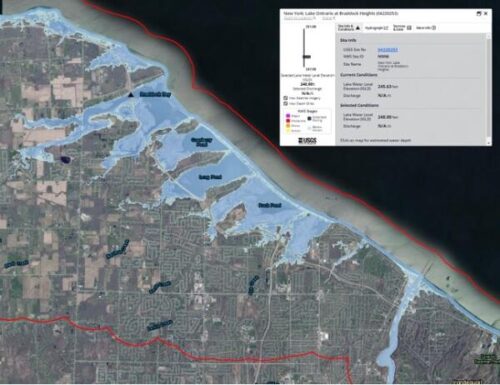
New flood inundation maps developed by the U.S. Geological Survey provide tools emergency managers and communities along Lake Ontario’s U.S. shoreline can use to visualize potential flooding at different lake levels. The maps, funded by the New York State Department of Environmental Conservation, will inform flood preparation, planning, and response and may inform decisions on issues ranging from road closures and evacuation areas to post-flood recovery efforts.
The maps cover 321 miles of New York shoreline and depict estimates of the area of inundation and water depth of shoreline flooding based on data collected from eight new USGS lake gauges.
Between 2017 and 2019, record flooding along Lake Ontario’s New York shoreline resulted in more than $1 billion in damages. USGS scientists installed 14 temporary water-level gauges in 2017 and monitored flooding through the lake’s recession. They also documented high-water marks, such as mud and debris on structures. The data from these temporary gauges and high-water marks helped identify the best locations to install the permanent gauges.
“The eight new gauges placed off the New York shoreline will give us much more insight into how Lake Ontario flooding will affect communities along the shore as well as inland,” said Christopher Gazoorian, the Surface Water Specialist for the USGS New York Water Science Center. “The gauges give us information that has not existed for this region of New York.”
The new gauges monitor lake levels in near real time and also provided the data used to develop the new series of flood inundation maps. These new maps are accessible through the USGS Flood Inundation Mapper (https://fim.wim.usgs.gov/fim/), an online tool that people can use to assess the potential for flooding at various places across the nation.
These gauges are not the only ones on the lake but are the first that produce data reflecting localized conditions affecting water elevation, such as wind speed and direction. Numerous rivers and bays feed into Lake Ontario, and an estimated 13,000 homes are in the region.
“New York State is leading the nation in advancing actions and investments to mitigate flooding fueled by climate change, particularly along Lake Ontario through the State’s Resiliency and Economic Development Initiative,” said DEC Commissioner Basil Seggos. “To bolster these efforts, DEC recognized the need to help shoreline communities prepare for future flooding using the latest science and data to drive solutions. We partnered with USGS to collect lake level data and develop a mapping tool to generate real-time information to help municipalities better prepare to protect public safety and local infrastructure.”
New York counties included in the flood inundation mapping project include Cayuga, Jefferson, Monroe, Niagara, Orleans, Oswego, and Wayne.
Provided information